
If you’re buying land and the listing says “shared access,” stop and slow down. A due diligence survey can protect you from one of the most expensive surprises in real estate: finding out your “road” works like a handshake deal instead of a real, legal right. And once you close, that surprise can turn into stress, legal fees, and neighbor fights fast.
Right now, Minnesota has a perfect example. A long-running gravel-road dispute near Mora (Kanabec County) returned to court on December 16, 2025. The argument sounds simple—whether “Hornet Street” counts as a public road or a private driveway—but the case dragged on, and the judge pushed the trial to February. It even spilled into local Reddit talk, because access fights hit a nerve for property owners.
So, let’s use that real story as a warning—and a guide—before you buy anything with “shared access.”
Why “shared access” feels fine… until it doesn’t
At first, shared access looks harmless. You see tire tracks. You see a gravel lane. You might even see mailboxes lined up. Plus, the seller says, “Everyone has always used it.”
But shared use does not equal shared rights.
Here’s what often happens instead:
- A path exists on the ground, but no clear record backs it up.
- Old documents name a road, but the road moved over time.
- One neighbor maintains it, so they feel they own it.
- Someone puts up a gate, and suddenly you learn you can’t force access.
That Mora dispute shows the ugly version of this problem. People argue over what counts as a road, what old records mean, and which proof matters most.
If you buy land with shaky access, you don’t just buy dirt. You buy a future argument.
What a due diligence survey actually does for you

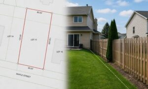
A due diligence survey gives you clarity before you commit. It doesn’t rely on vibes, memories, or “we’ve always done it this way.” Instead, it lines up records with the real world and shows where they match—and where they clash.
Think of it like this: if access drives value, then you should verify access like a professional.
A strong due diligence survey for shared access focuses on three things:
1) The record: plats, maps, and legal descriptions
Old plats often show streets, lanes, alleys, and right-of-way lines. However, those lines don’t always match what you see today. Still, plats give you a starting point. They also show intent—what the original plan claimed.
2) The rights: deeds, easements, and “who can use what”
This part matters the most. A driveway can cross land you don’t own, yet an easement can still give you the legal right to use it. On the other hand, a well-worn lane might have no easement at all. That gap creates risk.
3) The ground truth: monuments, corners, and occupation clues
Surveyors don’t guess. They hunt for boundary evidence—monuments, pins, irons, old marks, fences, and long-standing features. Then they compare those clues to what the records describe. If something looks off, they flag it early.
That same mix—records, rights, and ground proof—sits at the heart of the Mora case. And it’s exactly why due diligence matters.
The road-right surprises buyers see most often
Let’s make this real. These problems show up again and again:
“The road is there, so I can use it.” Not always. A road can look public and still be private.
“The county plows it, so it must be public.” Sometimes yes, sometimes no. In rural areas, maintenance stories get messy fast. People also confuse informal help with official duty.
“The seller said it’s fine.” Sellers don’t grant legal rights with a sentence. Paper does.
“My lender didn’t mention any of this.” Lenders focus on financing. You must protect yourself from risk.
So, if you see “shared access,” treat it like a flashing light. You can still buy the property. However, you should confirm the access story before you sign.
Smaller lots, Bigger consequences
You might think shared access only hits cabins and gravel roads. Actually, Minneapolis brings its own version of the same drama—just tighter, faster, and often more emotional.
For example:
- Two homes share a single driveway, and both owners assume they “own half.”
- An alley provides access, but fences, garages, and remodels blur lines over decades.
- Older plats create odd lot angles, and the “obvious” boundary doesn’t match the record.
- A new buyer wants to pave or widen a drive, and the neighbor says, “Not on my land.”
Because lots run tight, even a foot can trigger a fight. And once you pour concrete, you don’t want to rip it out later.
That’s why the same lesson from Mora applies here: verify access before you invest in the property—or improvements.
How to talk to a surveyor so you get clear answers
You don’t need fancy language. You just need clear facts.
When you call, say something like:
“I’m under contract on a property. The access looks shared. I want a due diligence survey focused on legal access and any boundary issues tied to that access.”
Then add what you know:
- What route you use to enter the property
- Any gates, signs, or neighbor drive crossings
- What the listing claims
- Any documents the seller provided (even if messy)
Also, ask the surveyor to explain results in plain terms. A good pro will tell you what they can confirm, what looks risky, and what needs more digging.
What you should do before closing
Even if you plan to hire a surveyor, do a quick reality check first:
Drive the access route slowly. Then ask yourself:
- Does it cross another parcel?
- Does it change shape or split?
- Does it run right beside a fence line?
- Does a neighbor treat it like “their” driveway?
Next, save photos. Grab a short video too. Those details help a lot, especially when records look old or unclear.
Most importantly, don’t rely on “everyone uses it” as your safety plan. That exact mindset fuels disputes like the one playing out near Mora right now.
The bottom line
Land can look perfect and still hide a bad access story. And when access turns fuzzy, everything else turns risky—your building plans, your resale value, even your daily drive home.
So if you see “shared access,” don’t panic. Instead, get smart. Due diligence surveys help you confirm what you can use, what you truly own, and what could spark a road-right surprise later.
Because nobody wants to buy land and end up in a fight over one question: “Is it a road… or a driveway?”