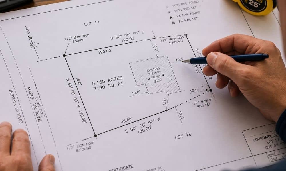
A plat of survey helps property owners understand boundaries, dimensions, easements, and physical features tied to a piece of land. In Minneapolis, where older neighborhoods, changing lots, and redevelopment projects are common, understanding a survey map can help you avoid expensive mistakes before buying property or making improvements.
Many people receive a survey and immediately look at the lines and numbers. Then confusion starts. Which line is the property line? What do all the symbols mean? What are those measurements around the edges?
The good news is that reading a plat of survey is easier than most people think.
What Is a Plat of Survey?
A plat of survey is a drawing prepared by a licensed land surveyor. It shows important details about a property and helps explain where the legal boundaries exist.
A plat of survey may include:
- Property boundary lines
- Lot dimensions
- Structures on the property
- Easements
- Utility areas
- Property line markers
- Driveways
- Setback areas
- Encroachments
Think of it as a map that explains what legally exists on your land.
Homeowners often receive one during a property purchase, renovation project, or before construction begins.
Start With the Property Boundary Lines
The first thing to identify is the actual boundary of the property.
Property boundary lines are usually shown using heavier or darker lines than other markings on the drawing. These lines define the legal edges of your property.
Do not assume a fence, tree line, or driveway automatically matches those boundaries.
This matters in Minneapolis because many homes sit in established neighborhoods where lot layouts were created decades ago. Features added over the years may not match original boundary locations.
When reviewing your survey, carefully trace the outside border first. This gives you the full picture of where your property begins and ends.
Look at the Dimensions and Measurements
Next, look for the numbers printed along the property lines.
These measurements tell you the exact size and shape of the property. Some lots are perfect rectangles. Others have irregular angles and curved boundaries.
Measurements are usually shown in feet.
Examples may include:
- 75 feet along the front lot line
- 130 feet on the side
- Curved measurements near streets or corners
These dimensions become important when property owners plan future projects.
For example, if someone wants to add a detached garage, backyard structure, or outdoor project, understanding available space becomes critical.
A few feet can make a major difference.
Identify Easements and Restricted Areas
An easement gives another party certain rights over part of your property.
Utility companies often use easements. Cities may also require them for drainage or access.
On a survey, easements are commonly shown with dashed lines or labeled areas.
Examples include:
- Utility easements
- Drainage easements
- Access easements
- Shared driveway areas
These areas do not necessarily stop you from using your property. However, they may limit where structures can be placed.
Many homeowners skip this step and later discover they built too close to a restricted area.
Always review these sections carefully.
Find Property Markers and Monuments
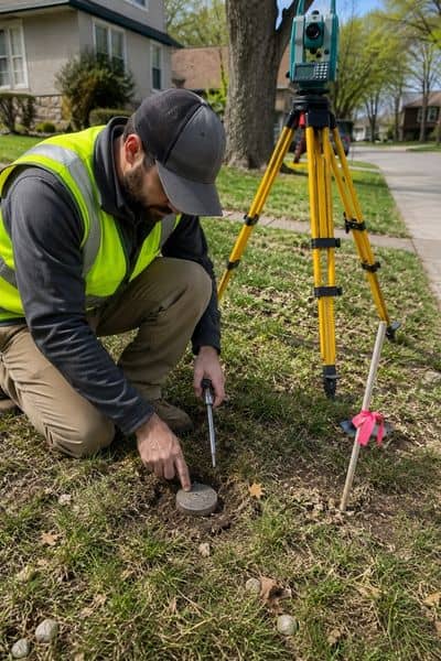
Surveyors often place or locate physical markers that identify property corners.
These markers can include:
- Iron rods
- Metal pins
- Monuments
- Survey caps
Your plat of survey may reference these locations.
Finding these markers helps connect the paper drawing to the real property outside.
In Minneapolis, freeze and thaw cycles can shift landscaping and make original markers difficult to locate. Landscaping projects, sidewalks, and older construction can also hide them over time.
If markers cannot be found, a licensed surveyor can help verify locations.
Watch for Structures Near Boundary Areas
Many surveys show structures that already exist on the property.
Examples include:
- Homes
- Sheds
- Garages
- Decks
- Driveways
Pay attention to how close these structures sit to property lines.
This does not always create a problem. However, structures located very close to boundaries may deserve closer review.
Sometimes improvements built years ago create questions that only become obvious when a property changes ownership or future projects are planned.
This is one reason buyers should review surveys before closing.
Common Survey Symbols Can Look Confusing
Survey maps often contain abbreviations and symbols.
Examples include:
- IP for Iron Pipe
- IR for Iron Rod
- MEAS for measured distance
- R/W for right-of-way
Do not panic if the document looks technical.
Surveyors use standardized symbols so information stays organized and readable.
If you do not understand a marking, ask questions before making decisions based on assumptions.
Reading one wrong line can lead to expensive mistakes.
Why Understanding a Survey Matters in Minneapolis
Minneapolis has many older residential areas where a lot of layouts have changed over time.
Property owners continue adding garages, patios, landscaping, and improvements throughout the city. Redevelopment projects also continue creating changes in many neighborhoods.
Understanding a plat of survey helps property owners make informed decisions before investing money into projects.
A survey can help answer questions before they become problems.
That simple review may save time, money, and stress later.
When to Contact a Licensed Land Surveyor
A survey document gives valuable information, but there are situations where professional guidance still matters.
Consider contacting a surveyor if:
- Property markers cannot be located
- Boundaries seem unclear
- Measurements create confusion
- Improvements sit near lot lines
- Construction projects are being planned
Surveyors do more than draw maps.
They help property owners understand legal boundaries and avoid future surprises.
Before buying, building, or making changes to a property, taking time to understand your plat of survey can protect your investment and help you move forward with confidence.