How To Find Your Property On FEMA’s Flood Insurance Rate Maps

What are FEMA flood maps?
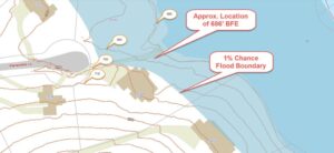
FEMA’s Flood Insurance Rate Maps (FIRMs) or just Flood Maps are provided after a flood risk assessment has been completed or updated for a community.  This study is known as a Flood Insurance Study.  The FIRM gives you the Base Flood Elevations (BFEs) and insurance risk zones in addition to floodplain boundaries.  The FIRM may also show a delineation of the regulatory floodway.

Once the “insurance risk zone”  (commonly referred to as the flood zone) is determined, actuarial rates, based on these risk zones, are then applied for newly constructed, substantially approved, and substantially damaged buildings.  FEMA uses these rates to determine the insurance rate you will pay for flood insurance

FEMA’s Digital Flood Maps

FEMA discontinued the production and distribution of paper flood maps in 2009 as part of its Digital Vision Initiative. This affected all the Flood Maps, boundary information, and study reports. However, clients can still view the products for free through their website or buy them in digital format.

To view these flood maps online, go to FEMA’s Map Service Center and key in your address (hi-lited area shown here) search for your home.  This will prompt you to then select the map that covers your area.  The Flood Maps are somewhat cumbersome to use online. It is best to go through the tutorial on the bottom right of the address search page for an easier and more effective use of the GIS map.

author avatar
Surveyor

More Posts

Engineer reviewing documents and maps on site before a property line survey
boundary surveying
Surveyor

Build the Perfect Property Line Survey Package

When you’re getting ready for a property line survey, it’s easy to think the hard part starts when the crew arrives. In reality, a smooth and accurate survey begins long before anyone sets foot on your property. The more prepared you are with records, maps, and documents, the faster your

Read More »
Total station used for an ALTA survey on a commercial construction site
alta survey
Surveyor

Top 5 ALTA Survey Mistakes That Delay Title Insurance

When you’re closing on a property, one document matters more than most — the ALTA survey. Lenders, title companies, and buyers rely on it to see where boundaries, easements, and improvements actually sit on the land. A clean and accurate ALTA survey protects everyone involved. But one small mistake can

Read More »
Aerial view of the Mississippi River and downtown Minneapolis showing bridges and flood risk areas connected to FEMA Elevation Certificate requirements
flood damage
Surveyor

FEMA Elevation Certificate: Protect Your Home Sale

If you’re buying or selling a home near the river or one of the city’s many creeks, you’ve probably heard the term FEMA Elevation Certificate come up. This single piece of paper could make or break a deal—especially right now, when there’s talk of the National Flood Insurance Program (NFIP)

Read More »
Construction surveyor using GPS rover on a job site with sun flare in background
construction
Surveyor

Construction Surveyor Guide to Solar Storm GPS Risk

When you hire a construction surveyor, you expect accurate measurements. After all, a few inches can make or break a foundation, delay a project, or cause costly rework. What many people don’t realize is that even the best technology has a hidden vulnerability: the sun. Recent news from NOAA about

Read More »
Surveyor conducting a boundary survey on a cleared urban site with safety gear and tripod equipment
boundary surveying
Surveyor

Boundary Survey Challenges After Site Encampment Clearances

When people think about a boundary survey, they often imagine a simple task: marking property lines so builders or homeowners know where one lot ends and another begins. In most cases, that’s true. But in Minneapolis right now, the job has gotten more complicated. After two recent shootings near Lake

Read More »
Drone surveying over riverfront land, capturing aerial data for land assessment and redevelopment projects.
land surveying
Surveyor

How Drone Surveying Is Changing Land Redevelopment Projects

If you’ve heard about Graco moving out of their big property along the Mississippi River in Minneapolis, you know this opens up a huge chance for new development. The site covers 40 acres of prime riverfront land. But before anything new can be built, surveyors need to take a close

Read More »